Alaska 2024

Day 17 July 18, 2024 Arctic Circle, Campground to Galbraith Lake Campground 161 miles

Pretty mountains

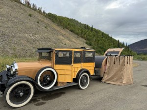
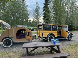
Well, the mosquitoes last night were horrendous. We opened the trailer door just to get in and so did about 100 mosquitoes. Took us a few minutes to get them all wiped out. This will be a challenge with that many mosquitoes.

This morning while we were having breakfast at the picnic table, the mosquitoes were not quite so bad. We did see a rabbit. It was a cute little brown one. It hopped away and didn’t make much of a fuss. We also saw a squirrel run through the trees. Fortunately, we did not see a moose or a bear, even though there was a path into the woods that looked like it would accommodate either.

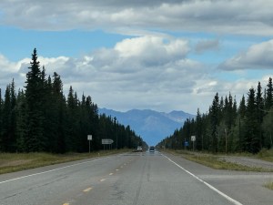
The day started out sunny but quickly turned cloudy again. We did get a brief shower, but nothing that would add up in any of the puddles.

Big cut in the road

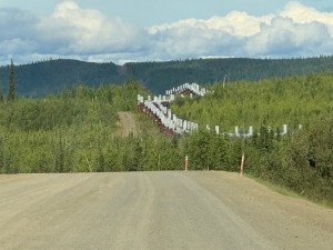
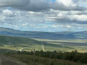
We have seen lots of the pipeline today most of it is above ground, but occasionally it dips underground. They excuse they give for going underground is for large animals to be able to cross.

Snow on the mountain

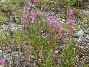
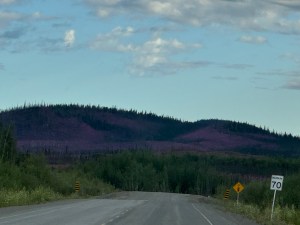
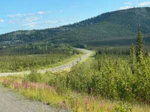
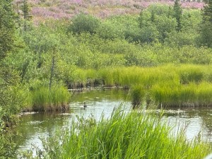
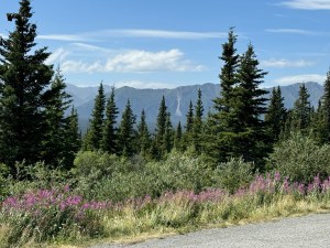
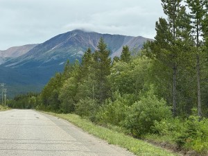
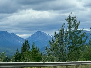
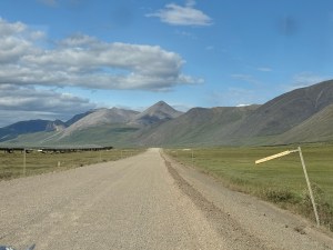
The terrain has been changing significantly. We have gone through forest with stunted trees and then tundra. One area had a forest fire go through. The ground was once again covered with the raspberry flowers. Learned later that those are called fireweed.

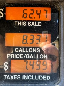
After about three hours, we arrived at the small community of Coldfoot. This was a good place to fill up with gas. We talked to several of the other folks traveling through about the road ahead of us. We got “you can make it no problem” and we got “I wouldn’t if I were you”. We did eat lunch here at a fairly reasonable price for where we were located. Then we went across the highway to the visitor center. Very helpful people in there. Wonderful displays about the area as well.

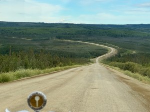
Rob decided that we should continue on. The suggestion from the visitors center was to go until we couldn’t anymore. We could always turn around and come back. There does seem to be one spot in the construction zone ahead that has been reported being very muddy. If it’s too muddy, we don’t think we can make it.

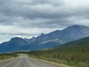
We had about 30 miles of asphalt going out of Coldfoot. Most of it was reasonable. But when it ended, it was a great big bump and Connie hit her head on the top of the car. Sure did hurt.

Past time to snug up the seat belts.

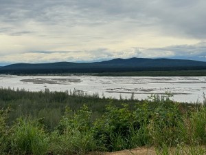
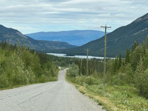
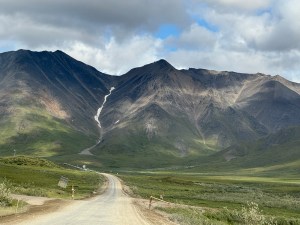
We drove along a river for quite some distance. It’s very shallow and spread out all over with gravel islands.

Waited for this truck to pass

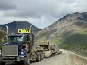
At one point a lead car for a large truck stopped us and suggested that we wait because the truck that was coming was quite long and quite wide. So we turned off the car and just sat there. Sure enough it was a long wide truck that came. Glad that we stopped.

Look at dust created by truck

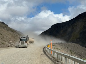
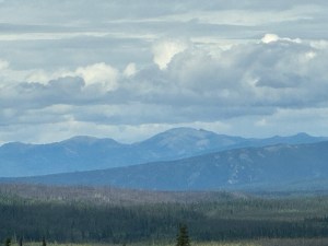
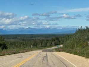
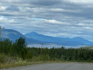
Then we came to the pass. Oh my goodness what a high pass that was. It must be a mile or more up the hill and a mile or more down the hill. The worst thing is there are no curves to speak of so it is a long long pull. The car on the way up did get hot so we had to stop and let it cool down. There are no escape routes anywhere on this road. There are virtually no wide spots to turn into. I really don’t know how those big trucks manage to get up and down without going off the edge. And it’s a long long way down.

Long straight stretch with pipeline nearby

Unbelievably, we saw three bicyclist today. I really think that would be hazardous to your health.

After about 100 miles we came to the turn off for the Galbraith Lake campsite. What they didn’t tell us back at the visitor center is that it’s almost 5 miles off the road. Then when we got there, we found out there are no drive-through parking spots. The road through the campsite is very narrow with lots of holes full of water so you can’t tell how deep they are. There’s no easy way to turn around. We finally made it back to the entrance. We decided to just park wherever we could find a reasonable spot. The mosquitoes here are also terrible. A couple came up to visit a little bit. They said they had gone on a hike this afternoon and were covered with mosquitoes.

Other than overheating once the car worked well today. It would be interesting to know if a four bladed fan would have kept the car from heating up.

Alaska 2024

Day 16 July 17, 2024 roadside turnout to Arctic Circle 151 miles

Last night we had a few raindrops so we went to bed a little earlier than expected. We changed clothes in the shower that pops up beside the trailer. We cracked the windows just a little and it was nice and cool all evening. Traffic did continue to go by all night but not as frequent.

Camping in a pullout

Early in the day, we encountered a portion of heavily burned forest. The ground is now covered with those raspberry colored flowers. Makes the hillside quite pretty. The pictures however don’t really show it very well.

Long road ahead

Now I think the tall skinny trees are actually black spruce. There’s a lot of it up here in the northern part of Alaska. And the further north, we go the shorter it gets. The ground has very little topsoil for the plants to grow in. Too much permafrost.

Some of the pipeline
Some burned area

We arrived at our first construction site. Did have to wait a little bit. But we’re the first in line. When the pilot car came, the driver could hardly believe her eyes. She asked us how fast we could go. Then said she would try to set that kind of pace. Two other vehicles pulled up behind us. We drove quite a ways behind the pilot car and then she stopped. She came back to tell us she had ordered another pilot car to take us so that she could take the other vehicles at a faster pace. They are redoing a large section of the highway and there is a great deal of activity going on. Our private pilot car actually went very slowly. At one point, we came along a piece of equipment coming up off the side at a 45° angle. At least half of the vehicle was suspended in the air. Could not get the camera out fast enough to take a picture, however.

Part of construction area

We came to the spot where the Dalton Highway begins. There was a sign posted that said speed limit 50 mph for the next 416 miles. Before long, the pavement ends and we are on dirt road. In someways the dirt road was a little better. The potholes were not as sharp. However, there were just as many of them.

Some pave straight road.

Next on the agenda came a detour. They are doing yet another section of the road and we were put on a new road that was very narrow very rocky and obviously not at the same quality as the rest. We thought maybe we were in the wrong place, but there was nowhere else to go. We eventually pulled off into a parking spot where there were two other vehicles. The passengers in those vehicles said they had turned around at Coldfoot because the road was so muddy they couldn’t get through. They indicated that even some of the trucks had turned around. We then talked it over and decided that we would try to go as far as the Arctic Circle, spend the night and then perhaps turn around and go back home.

Shortly there after the road joined back with the original Dalton Highway and the construction flagger was not far away. The line was quite long at this stop. We didn’t have to wait too long. We drove for quite a few miles with the pilot car this time through various different sections of the construction. They are completely rebuilding the road throughout here. New culverts, new sides, new everything I think. They’re working this section 24 hours a day. Best guess is they want to get it finished before the end of the summer. In some places, they are laying down a foam sheet before they put on the dirt. This is to help keep the permafrost cold. Sure hope it keeps out some of the bumps. Then we had to stop and wait because another pilot car was coming from the other direction. It makes a lot of sense that they would have two pilot cars due to the distance that they had to go.

We could see more sections of the pipeline above ground, and once again, it crossed the Yukon river and went under the bridge across the river. Now the bridge had a wooden floor. That wooden floor had potholes in it. Did not give me a very warm feeling about crossing that bridge. Especially when you know that there are so many big heavy trucks going across it at reasonably fast speeds.

Bridge across Yukon River

There is a small gas stop just across the river and outdoor toilets and a very small restaurant and gift shop. There’s also access to the river with a boat launch. We filled up with gas. Price of regular gas was $7.499 per gallon. That is the most we have paid on the entire trip.

Gas pump cost

We went about 4 miles further down the road and ate lunch at the BLM campsite. This is certainly not much of a campsite. It has five tables and five fire pits in one big gravel parking lot. The view isn’t even all that terrific. But the price is right. There is no fee to stay.

From this campsite, it is approximately 60 miles to the Arctic Circle. The road is not very good so it’s slow going. We go at about 25 mph if we’re lucky. We went over several hills that are nicknamed the roller coaster. That’s because they have a very steep incline up and a very steep decline down. The day is mostly cloudy and we did get a few raindrops but not too serious enough to turn the windshield wiper on.

Road crosses the pipeline and looks like giant 8

We stopped at another rest stop for a few minutes and encountered a tour group of people from Argentina. They are going north but we don’t know how far and then flying back. Not sure where back is either. They seemed very friendly, however.

The foliage has certainly changed. The trees are now all much shorter and fewer. There’s more brush and low lying grasses. All part of the tundra up here. Still no animal sightings of any kind other than ravens and chipmunks.

Us at the Arctic Circle

We got to the Arctic Circle sign. We took a picture of us and the car by the sign so we have officially gone past the Arctic Circle. We then continued on to the campground that is also run by the BLM. This campsite is quite nice with picnic tables, fire pits, drive-through spots, back in spots, pit toilets, all the amenities except hook ups. There is a small fee to stay in this one. We signed for the spot that we wanted and returned to pay the fee. We could hardly get the envelope into the deposit slot because there were so many in there that had not been picked up. This campground is not convenient for B!M personnel.

We return to have dinner and set up camp. There are trash bins and camper food storage very close to our campsite. We think that might be kind of handy since there is a big warning sign about bears and wolves nearby.

As a little side-note, they built the Dalton Highway in approximately five months. It took them approximately three years to build the pipeline. Both are hard to believe timelines.

The car ran fine today spending most of the day in first or second gear.

Alaska 2024

Day 15 space July 16, 2024 space Delta Junction, Alaska to parking lot on highway 149 miles

We left the apartment at approximately 9 o’clock. Filled up with gas and hit the road again. We saw a big section of pipeline that crossed one of the large rivers and was exposed above ground for a ways.

The terrain is more rolling hills not any big hills, but everything is covered with trees. The day is mostly cloudy with little chance of rain. Eventually, we came to a section where a high range of mountains can be seen on a clear day. Unfortunately today was not a clear day. We could see the bottom of the mountains and clouds covered all of the top. A very large river flows near the road. It’s extremely wide. I’m assuming somewhat shallow.

We encountered major construction at three times. All three times were pilot cars. Two of the projects were installing new culverts along the way and making a wider drainage system. The other one was actually reconstructing a large section of the road. That should be very nice when they get it finished. Wonder how long before the permafrost makes it a mess again.

We realized that Eielson Air Force Base is very nearby. We decide to stop so that Rob can get a haircut. This airbase has the second longest runway in North America. We got on base without any trouble and had to go quite a distance to get to the BX. Rob found the barbershop but determined there was quite a long line. Connie went into the shopping center and took a look around. She found a new sweatshirt on sale and a very clever T-shirt about moose. Connie returned to the barbershop where Rob was still waiting, and we both continued to wait for over an hour while the one barber did one person very slowly, very accurately. Rob finally did get his haircut and we quickly departed.

We are now headed for the Costco in Fairbanks. We’ve learned that they have gas, which is undoubtedly the cheapest in the area. We also plan to get muffins and more instant oatmeal. On the way we found a pickup that was very much on fire and had traffic slowed down. There’s actually a freeway leading to Fairbanks. Well like any Costco trip we did some impulse buying. The first item was a giant cherry pie. The cost for it was almost the same as one piece of pie from Fast Eddy’s the other day in Canada. The other thing we purchased was Odin noodles that you can heat up in the microwave. Thought that might be a nice change of pace.

Yukon River I think

We checked the GPS and determined that the Visitor Center was only a mile or so away from the Costco. They supposedly have lots of current information about the Dalton Highway. We thought it might be a good thing to check especially since it was that close. So off we went. When we drove up, we were the hit of the crowd that was outside waiting or just chilling perhaps. One guy who talked to us said he had just gotten back from there and thought that it was not as bad as most people seem to think. There were a couple of pretty rough sections, but if you take it slow, you should be OK. Just be sure you get off the road for the big trucks. We went inside anyway just to check with them. Found a very nice park ranger and talked to her. She gave us a new pamphlet about the Dalton Highway and talked a little about the camp sites that are along the way. Rob decided that it’s worth attempting.

Some of the yellow wildflowers

We got a ways out of Fairbanks and encountered yet another stretch of construction. Rob visited a little with a guy from the car in front of us and a little from the guy in the car behind us. The flagger was also informative and talked about places we might stay for the night. They both thought any of the large turnouts would be acceptable. You are far enough off the road to be out of the way of traffic. We drove a little further past the construction and did find a large paved pullout. Stopped there and set up camp for the night. Mosquitoes aren’t swarming so maybe it won’t be too bad. Also found the sleeping masks. Sunset today is at 11:55 PM.

Camping in large pullout
Fireweed that is very abundant

But wait, now the mosquitos are swarming!

Alaska 2024

Day 14 July 15, 2024 Discovery Yukon RV Park to Delta Junction Alaska 248 miles

Well we spent our first night in the teardrop trailer at one of many RV sites. Cozy but doable. Only problem is its daylight here most of the day and the trailer doesn’t have a way to block that out. Maybe we will need to add blackout curtains for another trip. We didn’t have any rain which was a good thing. Started with the fan going but soon turned it off. The solar system is working as planned.

Connie tried the shower last night and found it much better than the previous two nights. The park was very quiet all night and the road traffic soon quit. The plug in slots are pretty full. Still a few dry spots available. A family with a tent pulled in about 9:30 and ate dinner before going to bed. Some of the RVs look like they have been there for a long time. They also have tents for rent and a few cabins.

Prepping breakfast at the RV park

We cooked breakfast from the trailer pantry and then headed out. We actually got away a little before 8:00 am. Of course we also got up a little earlier because it was so light.

The road continues to be terrible but we are going a little slower. At one spot there were a bunch of very tall poles fairly close together. Evidently it is one of the trials to determine how to deal with the permafrost. They are measuring the temperature underground. We don’t remember the road being this bad when we drove it with the modern car several years ago. A few semis have been on the road and when they go so fast through the gravel portions they stir up a lot of dust. This morning is calm so the dust remains. Just about like driving through a dense fog.

Mountain of raspberry flowers

We came around a corner and the land in front of us was raspberry colored. A wildfire must have gone through the area and now the wildflowers have taken over. So there are black trees and raspberry colored flowers for acres in all directions.

More open area

We fueled in Beaver Creek which is a very small First Nation community. Gas was over $6.00 Canadian a gallon. You had to pay inside which isn’t unusual but they are missing the boat by not having cookies, muffins or cinnamon rolls for sale.

We saw another attempt to control the permafrost. This one attempts to let more cold air reach the frost layer. Not sure how the setup knows to let in cold air but not warm air. Some of the record lows have occurred near here. -81 degrees Fahrenheit with 165 days a year that don’t get above freezing. Sure don’t want to move here.

We soon came to the Canadian border crossing but we are still about 19 miles from the US border. No explanation for the big gap. Getting through the US checkpoint was very easy. They did have a dog that sniffed around the car but they didn’t even ask if we had fire arms. He did say the road in Alaska would be better. We sure hope so.

Some of the rock graffiti is along the road again. The composers put it in sandy stretches so many of the rocks are missing. Sure makes it hard to read.

Rest stop

We stopped at one of the rest stops. I think everyone came to see and talk about the car. One guy said his motorhome had broken down and he was waiting for help to come from Tok. He also said the stretch of road from here to Tok was terrible. Took him two hours to come about 40 miles. We had to slow down to maneuver the road to Tok as well.

Some bigger mountains again
One of several lakes

We ate lunch at Fast Eddy’s in Tok. Very busy place. Of course it is about the only place for miles. Most tourists were stopping but so were some locals. We also filled with gas before heading out.

Headed to Delta Junnction

Connie was very sleepy and so didn’t see much from Tok to Delta Junction. The road was straight and relatively smooth. Therefore sleeping even in the woodie was possible.

We are spending the night in Delta Junction in an upstairs room out of town. Another person also thought they had this room but someone got it all worked out.

Not much wildlife today. One long tail on a small animal, three rabbits (according to Rob), and lots of ravens. Still no moose, elk, or caribou.

Car still running well and the trailer just keeps following. It never seems to get very far away.

Alaska 2024

Day 13 July 4, 2024 Whitehorse Yukon to Discovery Yukon RV Park Yukon 245 miles

Here we go again

Connie let the hot water for the shower run for at least five minutes with no luck. A call to the office brought the response that others had reported the same and they were checking on it. The sink has no stopper and the bathtub stopper doesn’t fit. Next best solution is heat water with the coffee pot, put that on a wash cloth and add cold water for a sponge bath. And she was going to wash her hair. Needless to say there was no hot water this morning either.

We left the hotel about 9:00 am but had to stop for fuel. We soon started going through small stretches of gravel road similar to before. Still no sign they plan to pave it any time soon. This continued all day. In fact later in the day we looked forward to the gravel because it was smoother.

We came to one much longer section where the highway is being rerouted. We could see the old road off to the right side. All the signs were there as well.

Horses along the road

We are driving through a large valley that includes some ranch land. Wow actually space with fewer trees. The valley is surrounded by mountains but not real tall ones. A sign indicates this is open range and to watch for horses. My oh my they got it correct. A small group were grazing in the right-of-way. A little further down the road a group of three were right on the road. We slowed and they moved. Those and the ravens were the extent of the wildlife sightings for today.

Ice field mountains behind the clouds

The Milepost says the mountain to the right looks like a man’s face. Well that could be if we could get a good view through the trees. Connie thought she saw it or was it the other set of crags? Mountains, mountains everywhere.

The mountains on the other side still have snow. But after reading in the book it is actually ice. They have alpine ice fields. The only such ice below the arctic circle. We followed along them for quite a while.

The wind has been terrible so far. The skies are mostly cloudy but no rain. It did rain during the night because puddles are everywhere.

We filled with gas in Haines Junction along with most other vehicles. This is one of the larger communities in the area. They are a very active group with festivals and events all summer.

Lunch stop

We pulled out for lunch beside a pretty little creek. A young couple came and tried fly and cast fishing but soon gave up. If you could get out of the wind the temperature was very pleasant.

Well there is a first. A tandem bicycle pulling a trailer. We haven’t seen as many bicycles today. The Model A is definitely better.

We went over both the highest and second highest summits between Whitehorse and Fairbanks. They weren’t all that high at 3294 and 3293 feet respectively.

The highest mountain range in the Yukon comes into view. It includes the highest peak in Canada which is Mount Logan at 19,545 feet. Some glaciers on these. In fact you can get airplane rides near Burwash for a closer view.

Blowing sand
More sand

Lake Kluane is the next significant sight. This is the largest lake in the Yukon covering approximately 154 square miles. At one end of the lake it looks like steam is coming off the water. Turns out it is sand blowing off land on the opposite side of the road. Everything is covered in dust after that. We eventually had to drive through that blowing sand with very poor visibility.

Some of the higher peaks

Then the highway surface conditions get horrible. The patches of gravel are some of the smoothest. The asphalt portions have dips, rises and numerous potholes. Everything is rattling. If this is the good road I don’t want to see the bad road. Glad I had a seat belt or I might have bounced out.

Just liked it

We were both counting down the kilometers to the RV park. We will be sleeping in the trailer tonight because their cabins were all booked. Showers cost one Canadian dollar for 2 minutes. Time to get some change.

Alaska 2024

Day 12 July 13, 2024 Continental Divide Lodge British Columbia to Whitehorse Yukon Territory 188 miles

We went to bed early last night so we got up earlier this morning. Besides it gets light very early and the window shades are not that good. The shower is tepid at best and the water sprays everywhere. The shower stall is so small you can’t move out of the spray. For sure your shower is short. But we ran the water quite some time hoping it would get warm. The showers for the campground are labeled as cold. The water at the sink is very hot.

We went over to the little restaurant for breakfast. We determined that the lady who runs it makes her own bread, muffins and cinnamon rolls. We had one thick slice of toast with our meal which was tasty. Several people came in for coffee. One happened to be an English man who came here for a woman. He had served in the British army and lost one foot. His girlfriend is in the Canadian army as a chaplain.

The weather is mostly cloudy today and cool. We turned the fan on in the car and of course all the windows are closed. Traffic is not all that bad today. Mostly RVs with a few semis. No logging trucks even though there are thousands of trees.

Speaking of trees I think I have determined that the tall skinny trees are Western Larch. If that is so the needles turn orange and fall off. I have asked and so far no one seems to know but there are lots of them. I don’t think they log them because they are too skinny to make a 2×4.

One of many lakes

The road dropped back into British Columbia for 42 miles. If we had not had the Alaska Milepost book we would not have known.

We encountered a few short patches of gravel road. No sign that they plan to pave them. Makes no sense.

Some of straight road

We have been following The Milepost book which tells what things are along the road. We are now on the Alaska Highway which was built by the US Army Corps of Engineers in 1942. Most of what we saw today was trees, lakes, trees, rivers, trees, and creeks. Oh yes and more trees. There are turnouts often. Some are considered rest stops because they have a pit toilet. Many of the creeks were named by someone in the Corp.

Second longest bridge on Alaska Highway

We crossed the next to the longest bridge on the highway at 1,917 feet. The floor of the bridge is the metal grating that cause the woodie to swerve all over. The bridge is being replaced with what looks like the same kind of bridge. We took it slowly as advised. We stopped just before the bridge at a rest stop that supposed had a good place to take a picture. It most likely was good at some point but now the trees have grown up too much for picture taking.

Just across the bridge is the First Nation town of Teslin. Most vehicles were stopping here to gas up including us. The book told us to really watch our speed through here. Success, no speeding ticket.

We have been warned to watch for bear, moose and caribou. So far no sightings beyond the black bear at the beginning of the trip.

Woodie at the lunch stop
Dam at lunch stop

We stopped at the rest stop just before another bridge painted bright blue. Several others are stopped here too.

Bridge near lunch stop

We then crossed the third longest bridge at 1,770 feet has a concrete floor. This bridge was built high above the water so ships could pass under. Most of the ships stopped carrying supplies after the highway was built.

We arrived in Whitehorse about 3:00. This town is considerably larger so more traffic. They have a quilt shop so Connie headed out to see it. Great shop. She helped the local economy.

We ate dinner at a beer brewery that was obviously very popular. It wasn’t very big but was always busy. Connie tried a Two Percent Spritzer that Rob was eyeing. That is until he tasted it. Described as a bitter herby flavor.

Rob admiring Connie’s drink

No problems with our basic transportation today. However, it could use a good bath.

Alaska 2024

Day 11 July 12, 2024 Dease Lake British Columbia to Continental Divide Lodge Yukon 222 miles

Today is complete cloud cover and cooler. Only a few rain drops. We started the day by going to Charlie’s Repair shop to see about getting an oil change. He couldn’t do one but gave Rob an oil pan, a piece of cardboard to scoot under the car and oil disposal. So we pulled over to the side of his driveway and Rob changed the oil. Charlie called Rob vintage. We don’t think he has ever been called that before.

Metal rooster with caribou antlers

Then back to the gas station for a fill up before leaving. That gave us a late start of about 10:00 am. Fortunately we planned a shorter day. The gas station is also a small grocery store. Outside the grocery is a large metal rooster with caribou antlers.

Road scene

Not far out of town we encountered the first construction work of the day. They are crack sealing. That means they are filling the holes and cracks with road mix and then covering that with what looked like oil. They were using a pilot car that went much further than the work area. A semi actually passed us while we were all in the pilot car line. Never had one do that before. He must have thought the line was over.

More from road

Much further down the road another group was crack sealing another long stretch of highway. The weather must cause real havoc with the roads. They are all full of cracks, pot holes and bumps. We just keep bouncing along.

All along the route are lakes, rivers and creeks. Sometimes you can see a long stretch but mostly we only see glimpses through the trees.

We came to Jade City where they mine jade. Looks like a tourist trap to us but there are a lot of vehicles in the parking lot. Outside are numerous big rocks that have been sliced and polished to reveal the jade. The area produces about 1 million pounds of jade annually.

Oh my a wild animal. A porcupine was right beside the road. Glad it was not on the road. Those quills are deadly on tires.

Good Hope Lake

Next up was Good Hope Lake. This is a Native Nation town. They have gas and diesel but as we remembered from before they are only open limited hours and prefer to sell to Native Nation residents. So on we go.

We ate at a small turn out at the entrance to a provincial park. One vehicle stopped and took a picture and two French speaking bicycles also stopped. They had never seen anything like it.

Not sure

The landscape opened up into a large valley filled with trees. The mountains are further away and shorter. These are the oldest mountains in British Columbia. They are more like New England with evergreen trees rather than hardwoods.

Then we came upon a huge area that had been destroyed by wildfire. We didn’t ever see a date but it must not have been too long because new vegetation has not started. Many of the burned trees are laying on the ground like giant black toothpicks. The forest has been destroyed as far as we can see in all directions. A short section the hills are like giant mole hills all very close together.

Welcome to Yukon

At last we have reached the Yukon. Good bye British Columbia at least for now. A small sign says goodbye and a large sign says hello.

We filled with gas at the junction of the Cassiar Highway and the Alaska Highway. We have been traveling on the Cassiar Highway for several days. The Alaska Highway seems much smoother and wider. Probably explains the more semi trucks. Still lots of RVs in all sizes. The right-of-way between the road and the trees is considerably wider and full of wildflowers in all colors and sizes. In many of the sandy cuts words are spelled out in rocks. This was originally done by the Fort Nelson swim team in 1990. Many of those words are no longer legible because many of the rocks are missing. Other travelers have continued the practice however.

Our lodging tonight is at the Continental Divide Lodge. We pulled into their gas station. The clerk came running out saying we were the coolest thing she had seen come off the highway. We even got a discount on the room and a free load of laundry.